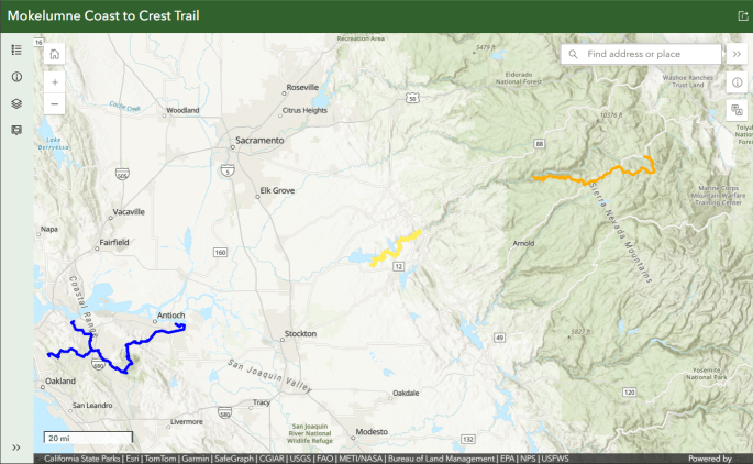
Click image and zoom in on the orange trail in this Mokelumne Coast to Crest Trail map
- Blue – East Bay – Contra Costa County
- Yellow – Camanche – Pardee
- Orange – Upper Mokelumne River Canyon
- Delta and Middle Mokelumne Segments are not reflected here, their alignment is not defined
After downloading waypoints (KMZ file) to a laptop or phone, view in a GPS app like Google Earth.
Description
- West boundary is at Tiger Creek Reservoir. This is also the western end of the Stanislaus National Forest
- East boundary at Ebbetts Pass in Alpine County
- Located in both Stanislaus & Humboldt-Toiyabe National Forests and Carson-Iceberg Wilderness
- U.S. National forests and wilderness areas are owned by the public and open to hiking, equestrian use and mountain biking, except for a mountain bike ban in wilderness areas.
Visit our trail partner US Forest System’s dedicated page to the Mokelumne Coast to Crest Trail to learn about visiting this segment.
Day Rides & Hikes
Moderate Mosquito Lake to Pacific Valley
Challenging High Country Meadows Trail
Difficult Pacific Crest Trail
Activities
Hiking, biking and horseback riding activities can be combined with camping at designated campgrounds or within the forest and wilderness area (no mechanized devices allowed in Mokelumne Wilderness). Also consider fishing, swimming, birding, wildflower walks, bouldering, mountaineering, highpointing, peak bagging, snowshoeing, & nordic skiing.
Biking – Recommended for experienced riders
- Water – there are some seasonal water sources on or near the trail. All water found on the trail must be treated before drinking.
- Caution – Be prepared for sudden weather changes, strong winds, and high altitudes. Besides a GPS, please carry a map, as there are many unmarked trails and fire roads that cross the MCCT. Mountainous terrain results in less than optimal GPS fixes.
- If you come in from the lower altitudes, beware… the elevations is 7000′ or more in the high country. Give yourself a day or two to acclimate.
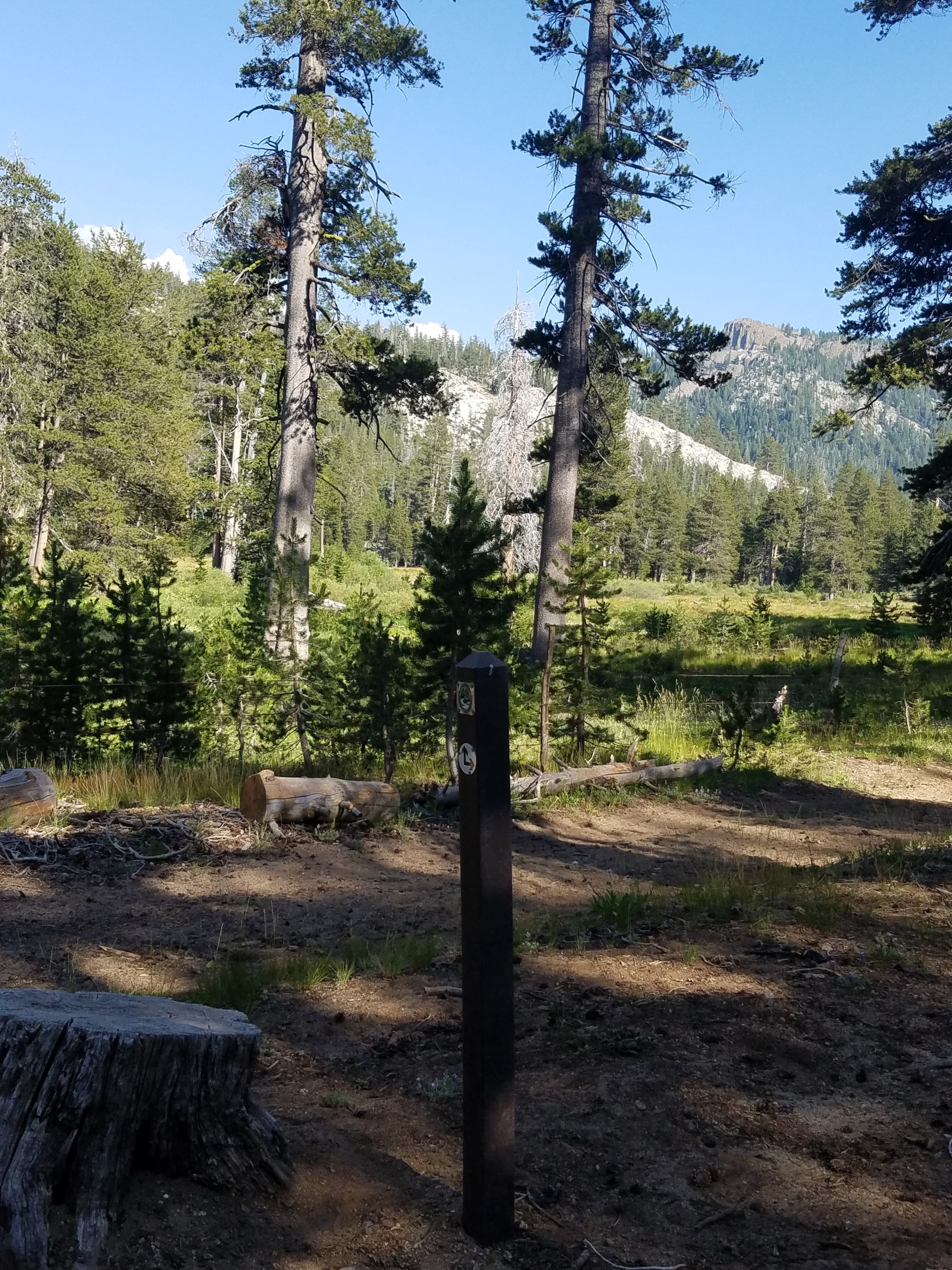
- Signage – Where the trail is signed it is marked at intervals with square green, beige and white logo signs on 4×4 trail posts.
- Leave-No-Trace—The MCCT Council supports and encourages LNT practices while on the trail.
- Camping – is allowed along the trail unless otherwise designated.
- Stop in for a Wilderness Permit before trekking into the Mokelumne or Carson Iceberg Wilderness areas east of Salt Springs reservoir and east of Lake Alpine.
- Fire – Fire danger can be extreme, and fires, camp stoves, and smoking may be prohibited. Check trailhead kiosks or call the USFS (209-795-1381) for current regulations.
- Side Trips – from the MCCT one can enter Bear Valley or Lake Alpine for lodging, B&B, cold beer and meals. Various professional recreation businesses also base themselves in Bear Valley. Corral Hollow Hill (elev. 8170′) is the tallest peak in Calaveras County. Along Hwy 4 east of Lake Alpine are numerous trails leading north and south, too numerous to list here.
Trail Conditions
The trail from Moore Creek east (3200’) to Lake Alpine (7,388’) varies widely in grade, watch for steep rocky sections around Garnet Hill & between Mattley Meadow & Jelmini Basin. This route is unshaded & semi-shaded.
Trail from Lake Alpine to Ebbetts Pass varies widely in grade. Not all junctions are marked yet. USFS is projected to complete signage by end of 2016.
Access
See trailheads below for information.
Vehicles with and without horse trailers should review recent changes to the U.S. Forest Service Stanislaus National Forest motorized travel system & dispersed camping.
Wilderness Areas east of Salt Springs reservoir and east of Lake Alpine are under special rules. Read more here.
Winter highway travel is open above Arnold on Hwy 4. Cross-country skiing and snowshoeing are open at Lake Alpine but parking requires a Sno-Park permit. Permits are available for a fee online and at Bear Valley Cross Country Ski Center, SNAC in Arnold, Ebbetts Pass Sporting Goods in Arnold, and at USFS Calaveras Ranger District office in Hathaway Pines. Find more information here & season permit prices here.

Trailheads
Moore Cree k Campground take Ellis Rd off Hwy 88 in Amador County and drive down a paved road to the Mokelumne River.
Mattley Creek Trailhead is between Moore Creek and Bear Trap Basin and is difficult to access by vehicle.

Bear Trap Basin staging location in Calaveras County, on 7N09 off Hwy 4 above Arnold and drive along dirt road, staying to the right at various junctions until it’s end in the Basin next to the kiosk. Check with USFS Calaveras Ranger Station for conditions and seasonal closures.
Corral Hollow trailhead is at poorly-marked Forest Service road 7N35 just off the northside of Hwy 4 in Alpine County just east of Tamarack and a tenth of a mile west of the Alpine county line. Limited parking for cars only. Challenging trail leads up the ridge face on 7N35 and connects with the MCCT. Turn left on the MCCT (west) 1.3 miles up the trail, before the ridge line. Watch for motorized vehicles on 7N35; it can get quite dusty in summertime. Trail leads to Bear Trap Basin.
Bear Valley staging location is in Alpine County adjacent to Blood’s Meadow and across the highway and a mile or so east of the town of Bear Valley. Primitive conditions for camping with horse trailers are here, watch for off-limit areas to horses and vehicles near the tennis courts and baseball field. Trail leads to Lake Alpine.
Lake Alpine is the site of a developed campground and recreation area.
Various trailheads between Lake Alpine and Ebbetts Pass Stanislaus Meadow, Mosquito Lake, Pacific Valley, Tryon Meadows, Highland Lakes, Gardner Meadow – any of these offer one-day hikes and multi-day trips
Ebbetts Pass
 MCCT’s eastern boundary is Ebbetts Pass, along the Pacific Crest Trail.
Accomplishments to date by U.S. Forest Service
- Opened trail between Lake Alpine and Ebbetts Pass
- Signed a portion of trail junctions between Lake Alpine and Ebbetts Pass
- In September 2015, built 1.1 mile trail connecting Mosquito Lake and Pacific Valley
- Set alignment between Lake Alpine and Ebbetts Pass
- Completed ADA accessible 2 mile trail at Lake Alpine (MCCT alternate)
- Completed 2 mile trail between Lake Alpine and Bear Valley
- Completed 15 miles of trail between Calaveras Dome and Bear Trap Basin
- Installed trail signs and kiosks from Calaveras Dome to Alpine County line
Accomplishments to date by Mokelumne Coast to Crest Trail Council
- Complete sign inventory between Lake Alpine and Ebbetts Pass, July 2016
- Installed trail signage at Moore Creek and Forest Service road 7N58 towards Garnet Hill
- Explored and mapped potential routes for the MCCT segment on various existing roads and trails between Moore Creek and the Pacific Crest Trail at Ebbetts Pass
Recent project status
All sections are built and open east of Moore Creek trailhead. Some junctions lack trail signs between Lake Alpine and Ebbetts Pass.
Trail signposts and kiosks were installed on 15 miles of trail between Moore Creek and Corral Hollow before snow season in 2010.
Remaining Work to Complete Segment
- Install all junction and trailhead trail signs
- Fill kiosk windows with brochures and trail guidance and safety information
- Update USFS paper and online maps
- Complete trail planning between Moore Creek and Tiger Creek, secure funding & build & sign trail
Partners
U.S. Forest Service
Contact: Casey Jardine 209-795-1381
California State Horsemens Association
Contact: Joseph Chavoen
Upcoming Events and Volunteer Opportunities
Possible volunteer opportunity installing junction signs. Contact Casey Jardine or the Calaveras Ranger Station at 795-1381
Recent Events
US Forest Service signed portions of Lake Alpine to Ebbetts Pass. Volunteers geomapped new trail segment between Mosquito lake and Pacific Valley. MCCT Trail Council installed proposition 40-funded trail posts at Moore Creek. Hardy Custom Builders (Jan Schmidiger) constructed and installed kiosks at Moore Creek and Bear Trap Basin.
2010 Trail sign and kiosk installation
Lodi Sentinel Staffers trek from the Mokelumne River headwaters at Highland Lakes down country to Salt Springs Reservoir Trip Report
We hope you enjoy the MCCT in the high country! To receive additional information, contact:
Mary Boblet, Segment Coordinator 209-287-2268, mboblet@gmail.com

what do the different colored map segments mean? is there any way to add a legend beneath the map?
Hi Zach,
Apologies for no legend. I posted before I had completed the google map and because most of the trail isn’t signed yet and we don’t think it’s a good idea to put people on it without signs or maps. Late this summer, as in the day before the first snow storm, we finished building and signing 15 miles of trail, between Moore Creek and Corral Hollow. I’ll put up a new google map sometime this winter. Let us know if we can help you further!
Mary Boblet
Is the section from Tiger creek to moore Creek going to be open this year?
Matt
Hi Matt,
This segment is open and signed (when the snow finally melts or by snowshoe!) between Calaveras Dome and Bear Trap Basin, which is approximately 15 miles.
There is still an unbuilt +/- one mile piece of trail between Garnet Hill and Calaveras Dome. The Forest Service plans to construct it this summer.
Check out our High Country Meadows Trail for more details on this segment. We will post a message here when the final piece opens!
Regards,
Mary Boblet